

Featured Image: Todd the Hiker standing beneath Star Gap Arch. Photo credit, Leah Nystrom
And he [Jesus] said to them, “Come away by yourselves to a desolate place and rest a while.” For many were coming & going, and they had no leisure even to eat. ~Mark 6:31
Escaping the Fall Crowds in Red River Gorge
One complaint I hear when talking to people familiar with Red River Gorge is that it is too crowded. You will certainly encounter quite a few people, especially on the popular hiking trails on a beautiful fall weekend, but you can escape the crowds if you are willing and able to be a little more adventurous.
Our early explorations in Red River Gorge focused primarily on the official trails with an occasional off-trail excursion and many repeated hikes on our favorite trails to introduce friends and family to this amazing little corner of God’s creation. One fall, several years back, we planned a couple of overnight backpacking trips to the gorge. And, rather than sticking to the official trails we decided to go deeper, exploring two of the longer unofficial trails on our outrageGIS maps and also described in Jerrell Goodpaster’s book, “Hinterlands.”
Before highlighting a couple of the trails we have explored I want to offer a few tips and notes of caution on hiking and backpacking off-trail in Red River Gorge.
Know Your Limits: I don’t want to make it sound like these are high-risk, extreme hikes comparable to climbing Mt. Everest, but at the same time there are plenty of dangers that cannot be ignored. Even on the official trails in Red River Gorge there are many high cliffs and rocky paths where one could easily slip, fall, and sustain a serious injury, or worse! These risks are compounded when hiking on unofficial trails. If you are injured and unable to walk, you are further from help and it is less likely other hikers will just happen along to provide assistance. There are also many areas where cell service is sketchy or even non-existent. If you are an inexperienced hiker, I recommend sticking to the official trails until you have a few more miles under your belt and are confident with rough terrain and longer distances before venturing out on these unofficial trails! There are so many great places to explore and amazing things to see on the official trails in Red River Gorge that you really do not need to take the risk.
Be Prepared: Even if you are only going out for the day, you still need to be prepared. Wear proper clothing and bring plenty of water (at least 2 liters per person for a day hike) and something to eat. You should also carry some form of emergency shelter (a 55 gallon trash bag will do), a whistle, a headlamp or small flashlight, a way to start fires, a knife, a first-aid kit, and, last but not least, a good topographic map and a compass (even if you carry a GPS unit). Handheld GPS units are nice, but batteries die (carry extras), LCD screens can get cracked (personal experience), and reception can be poor or non-existent especially in deep valleys with heavy tree cover. Take time to learn how to use a map and compass. This is an important skill to master if you have a desire to go deeper into the wilderness. A book I have owned since childhood, and one of the best on the subject, is “Be Expert with Map & Compass” by Bjorn Kjellstrom and Carina Kjellstrom Elgin.
Finding Your Way: Difficulty navigating is a concern. Even though many of the unofficial trails are well traveled, especially in the first half-mile or so, there are no signs, trail blazes, or navigational aids of any sort. As you get further off-the-beaten-path, these trails can be quite overgrown and difficult to follow. There are also many side trails that can cause confusion finding your route. A good map is essential. The USGS 7.5 minute topographic maps are helpful for understanding the terrain, but generally do not show even the official trails. The outrageGIS Red River Gorge Bakpaking Map is the best I have found for actually exploring the area, showing even the smallest unofficial side trails, the best views, and all the established campsites. Goodpaster’s book is a great companion to these maps, providing detailed descriptions of the unofficial trails with GPS coordinates, elevation charts, trail ratings, and more. With some experience in wilderness navigation and these two resources, you should have no problem finding your way around the backcountry trails of Red River Gorge.
Backcountry Camping: Most of the unofficial trails can be explored on day hikes, but there is nothing like the serenity you can find while backcountry camping in Red River Gorge! Watching a sunset while eating dinner perched on a rock outcropping overlooking the valley below or listening to the call of a whip-poor-will while gazing up at a blanket of stars on a clear summer night are just a couple of things you won’t get to experience on a day hike. If you plan to do any backcountry camping in the gorge, there are a few things you need to be aware of:
Recreation Fee Pass Required: You will need to purchase a recreation fee pass ($5/1-day, $7/3-day, $50/1-year as of January 1, 2022) in order to park overnight in the gorge between the hours of 10 PM and 6 AM. Fee passes can be purchased at the Gladie Visitor Center or any number of vendors in the area (both gas stations in Slade just off of the Bert T. Combs Mountain Parkway sell them). You need to fill out the starting date of your trip on the pass in non-erasable ink and display it on the dash or rear view mirror of your vehicle with the date facing out and clearly visible. (Note: you do NOT need to purchase a pass if you are only day hiking.)

Where to Camp: There are no official backcountry campsites in Red River Gorge, but there are many well established campsites along the unofficial trails that you will find marked on the outrageGIS maps. These sites are easily accessible, generally clear of underbrush and vegetation, and most already have rock campfire rings. So, while there are no rules that prohibit creating new campsites (within the restrictions listed below), there is really no reason to go the DIY route. Using an existing campsite minimizes impact on the area and is less work.
For all of the regulations on backcountry camping, fires, etc. see the USDA/Forest Service website, but the basic guidelines are as follow:
Camping is not permitted:
– in any picnic area or parking area.
– within 300 feet of any road or developed trail.
– within 100 feet of the base of any cliff, or the back of any rockshelter.
– within 600 feet of Gray’s Arch.
– within any area posted “No Camping.”
Availability of Water: The key point to emphasize on this topic is that there are no water sources at the trailheads. Also, many trails run along the top of ridgelines where there is no easy access to natural water sources. Even if you plan to camp in a valley where a creek is shown on the map, keep in mind that some of the smaller creeks are seasonal and do stop flowing during drier times of the year. If you are planning to treat your own water you may want to consider the possibility that the distance to the nearest natural source may be further than just packing in the water you need and hiking back to your vehicle at some point to resupply. You should always have a way to treat water in an emergency, just realize that sometimes it may not be the best option for your primary water supply.
Food Storage Restrictions: Even if you are camping in a developed campground, like Koomer Ridge, you still must ensure that all food, trash, and any scented or odorous items that might attract bears are properly stored. The approved storage methods applicable for backcountry camping include bear-resistant containers or a bear hang. (Note: food storage restrictions do NOT apply if you are only day hiking.)
Be Considerate of Others: Whether day hiking or camping, but especially when you are backcountry camping, remember that most people are there to enjoy the peace and serenity of the outdoors. Nobody wants to hear your obnoxious, drunken hollering at 1 AM in the morning, so just zip it! Besides, high cliffs and a high BAC generally are not a good mix. Also, if you pack it in, you need to pack it out. Clean up your own trash and pick up anything you might find that has been left behind by others. As for campfires, make sure there are no bans in effect, collect only as much downed wood as you need, and most importantly, make sure your fire is completely out before you depart. Finally, though many have already carved their marks on the rocks and trees of the gorge, there is no reason to add your signature to the page.
A Tale of Two Trails
On two beautiful weekends in the fall of 2014 we took advantage of nice weather to hike a couple of unofficial trails we had not previously explored and enjoy some backcountry camping. The first trip was September 26th and 27th, just as the fall colors were staring to appear. And the second was October 24th and 25th which was likely the peak weekend for that year’s fall colors.
The trails we hiked both weekends are off of the Double Arch Trail (#201). The first 1.4 miles of this trail were originally a part of Tunnel Ridge Road that has been closed to vehicular traffic for several years. Some older maps I have seen show this as an active part of Tunnel Ridge Road. However, regardless of what your map might show, this is now a hiking trail and you need to park at the Auxier Ridge trailhead. As these are unofficial, unnamed trails, I will refer to them by the names Goodpaster uses in his “Hinterlands” book. On our first trip we hiked the Star Gap Arch Trail (pg. 218), and on the second trip we hiked the Jailhouse Rock Trail (pg. 163). We camped in different spots on each trip, but both campsites were located near the beginning of the Star Gap Arch Trail.
Here is a rough map of these two trails I have drawn in Google Maps which also highlights a few key landmarks. I do not suggest using this map for navigation purposes, but it should give you a good overview of the area.
I will forgo detailed descriptions of these hikes and share the beauty of the two trails through photographs and brief captions. As the old saying goes, “a picture is worth a thousand words.” So here are several thousand, unwritten words for you to enjoy.
Star Gap Arch Trip (September 26th & 27th 2014)
 Campsite at sunrise from our Star Gap Arch trip.
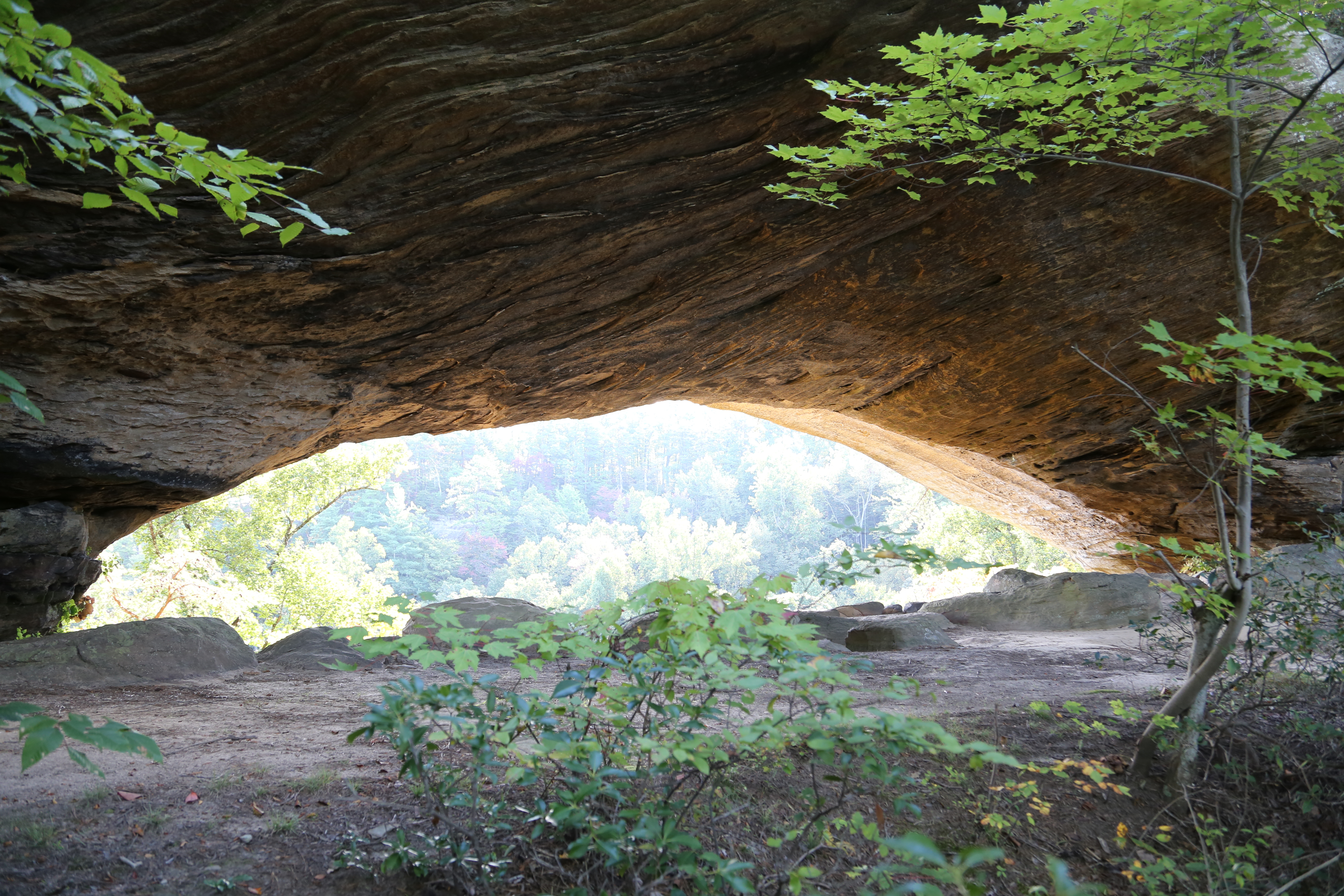 Star Gap Arch.
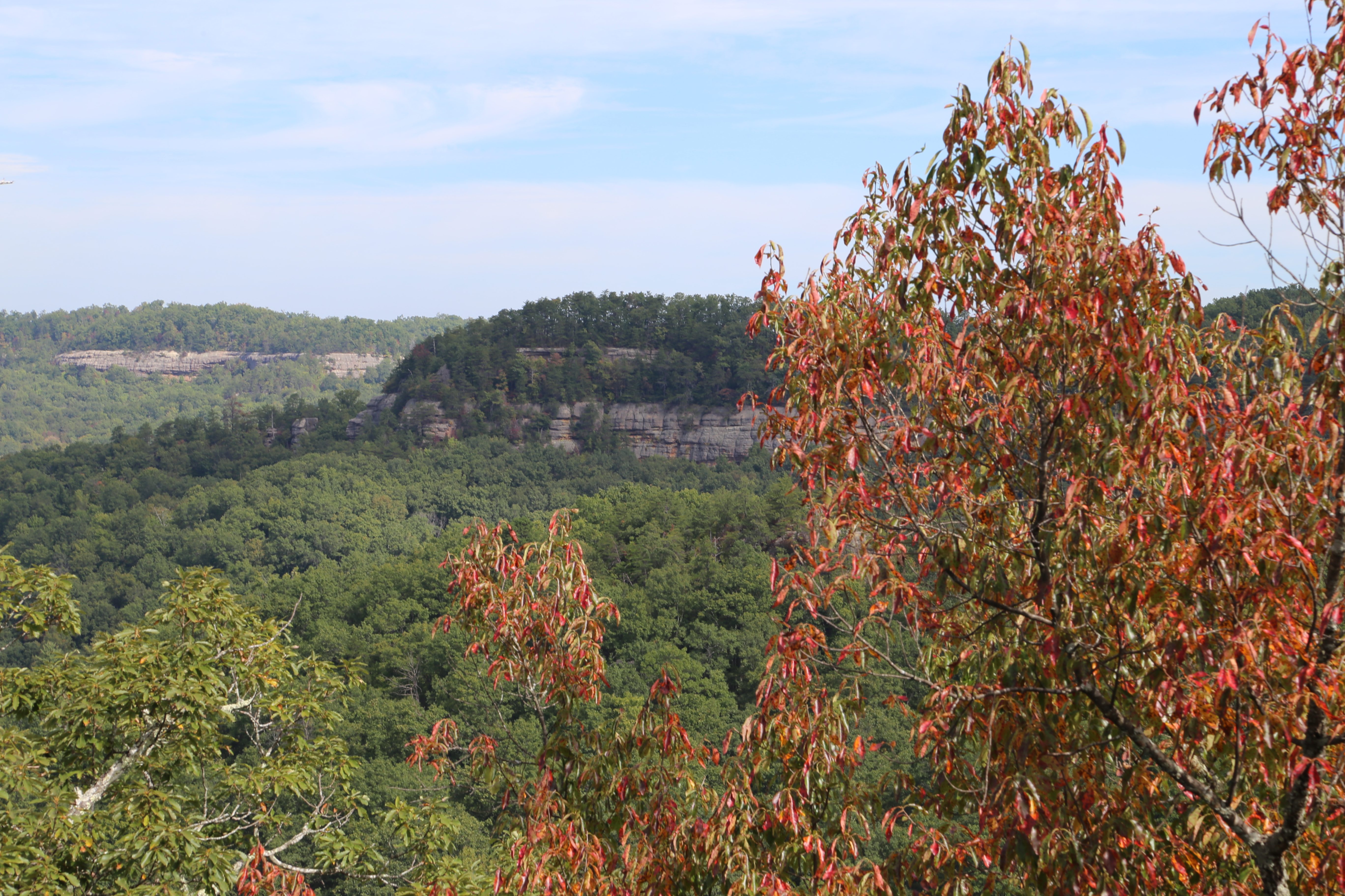 View looking north from the Star Gap Arch Trail.
 View looking west from one of the Star Gap Arch side trails.
 The final climb on the Star Gap Arch Trail. The views are worth it!
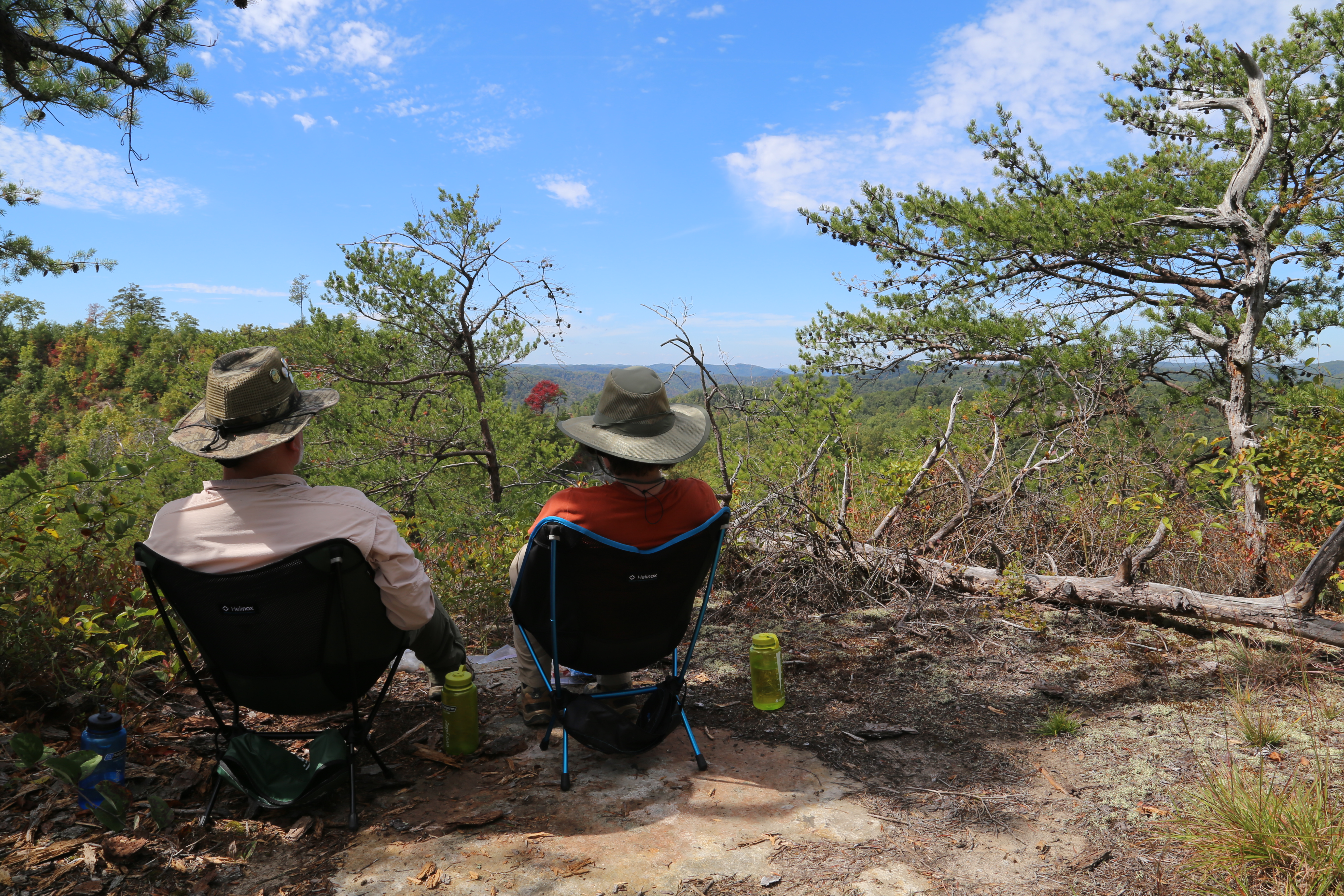 At the end of the Star Gap Arch Trail enjoying lunch and the view in comfort with our Helinox Chair One backpacking chairs.
Jailhouse Rock Trip (October 24th & 25th 2014)
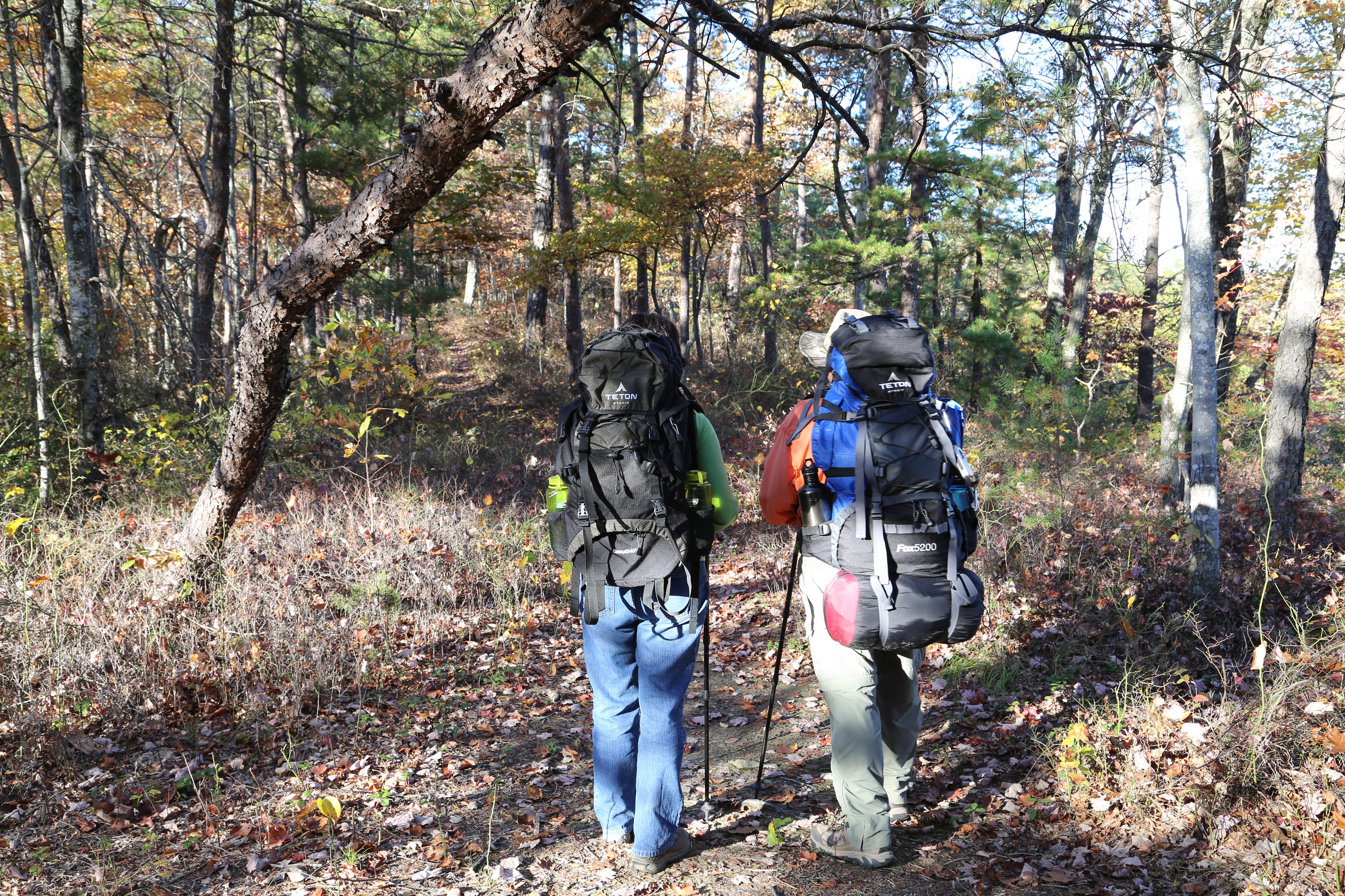 Are you interested in starting to backpack? Teton Sports has some good gear to get you started without breaking the bank. This was our first trip with their Scout 3400 and Fox 5200 backpacks.
 When backcountry camping in the gorge you always have a dinner table with a view!
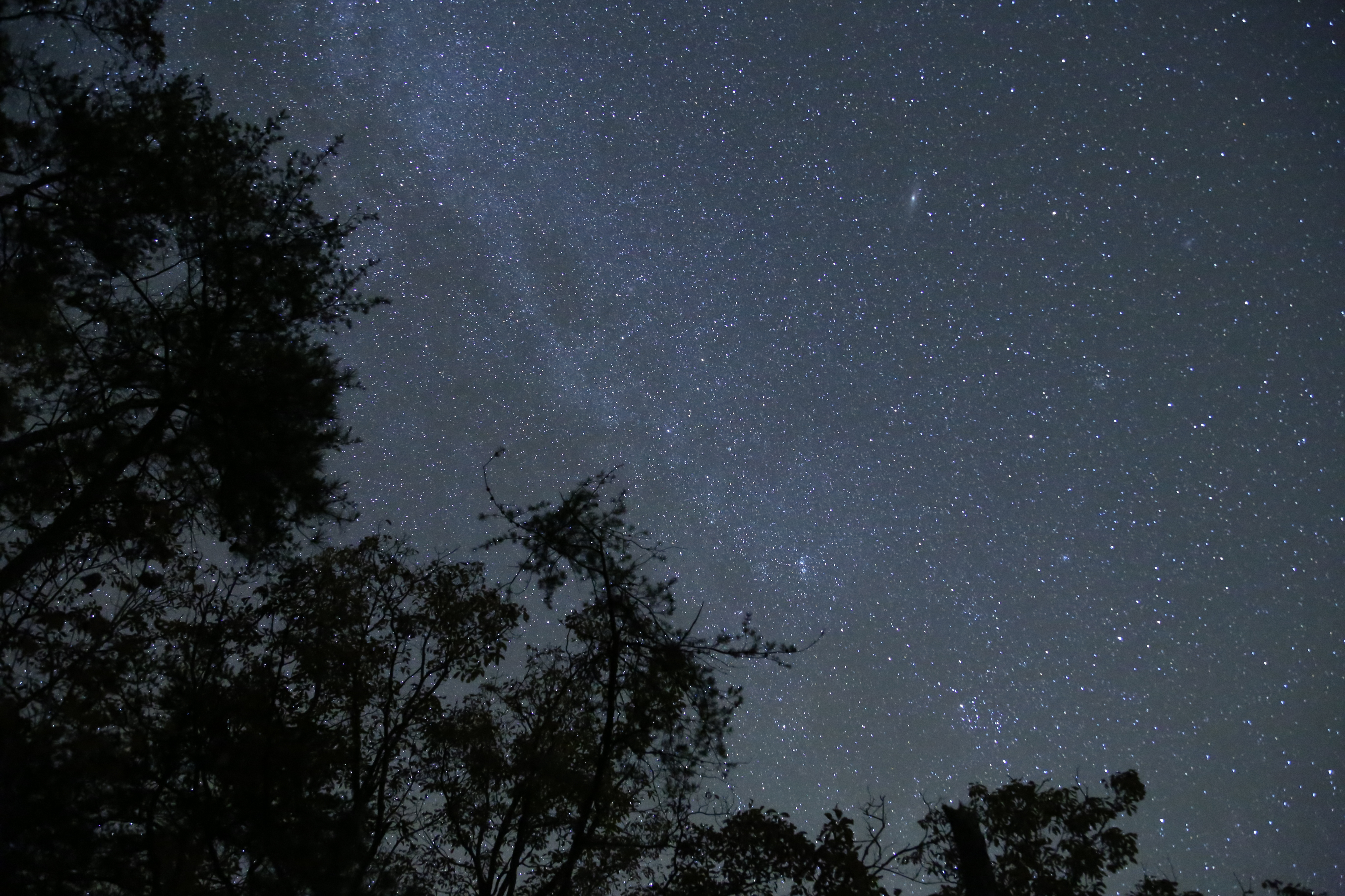 Here are a few billion reasons to go backcountry camping!
 View of Star Gap Arch from the Jailhouse Rock Trail.
 Looking west on the Jailhouse Rock Trail.
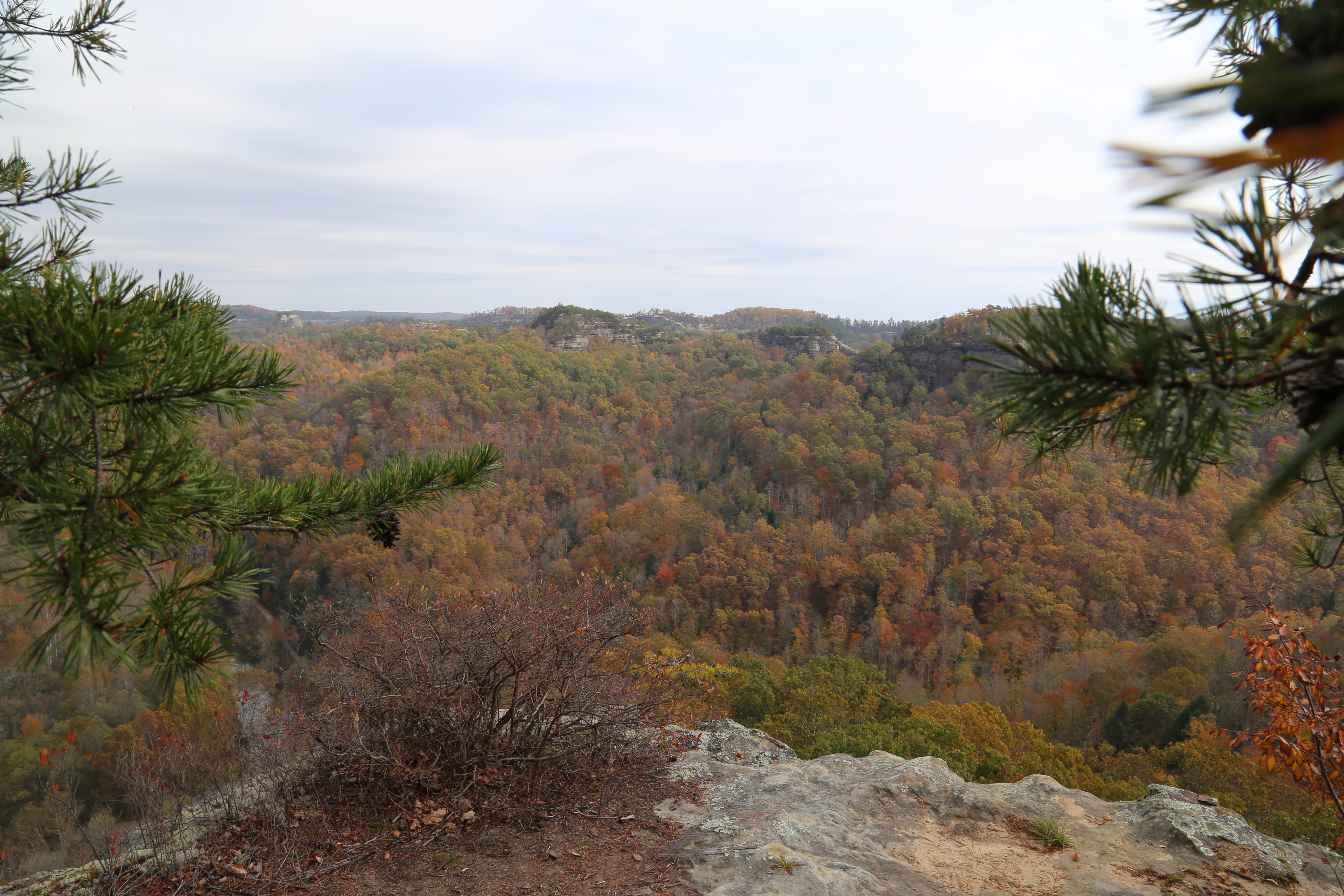 The view from Jailhouse Rock includes Courthouse Rock, Double Arch, Auxier Ridge, and the Red River.
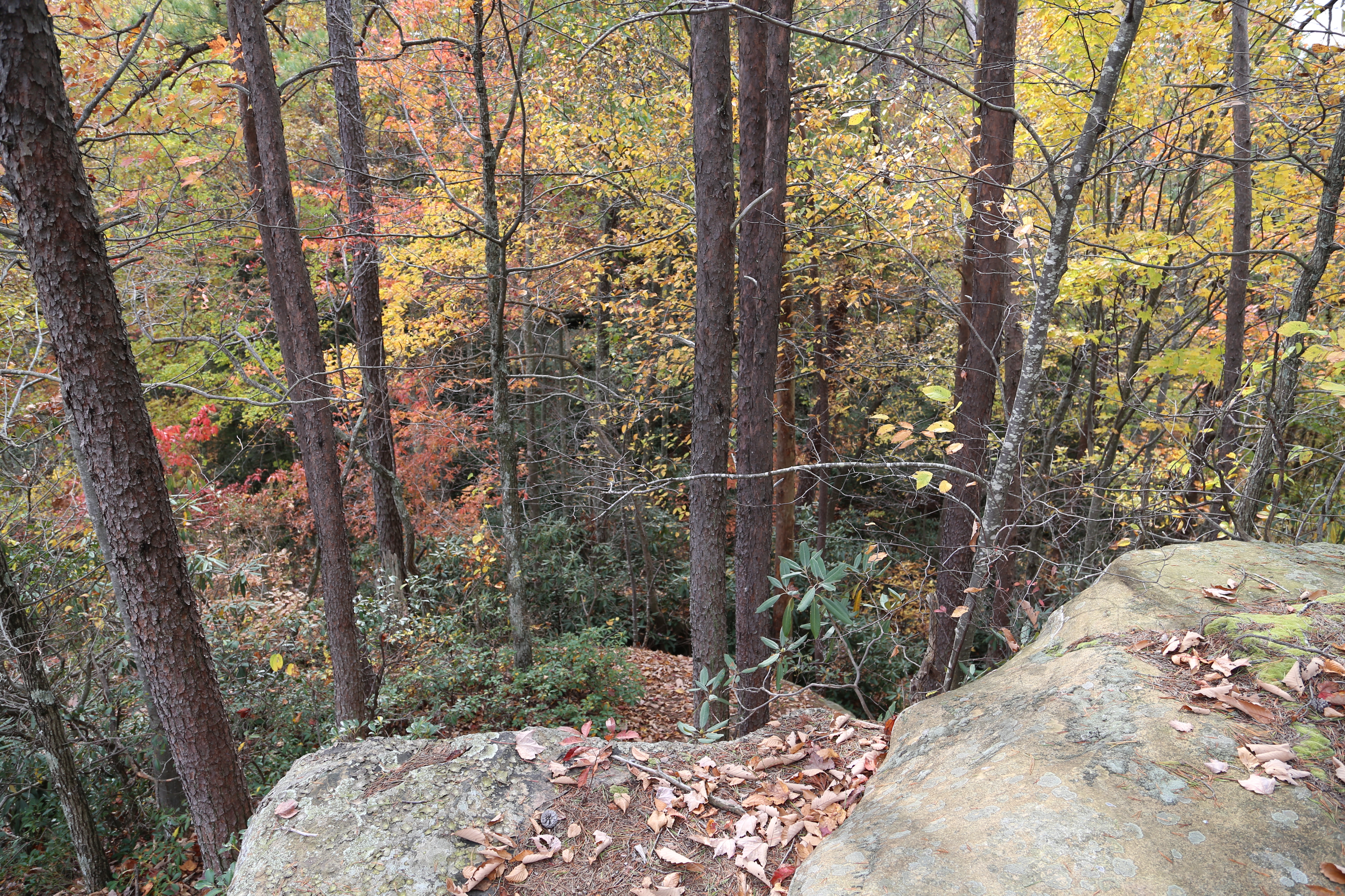 There is a trail here somewhere.
Both of our trips were on fall weekends with near perfect weather; and, although we were hiking from one of the busiest trailheads in the gorge, we still found plenty of solitude. The second weekend was one of the most crowded we have experienced in terms of the number of cars and people at the trailhead! Yet, after hiking past a camp site about 1/4 mile down the Jailhouse Rock Trail, we only had brief encounters with six other hikers, a group of three, a couple, and a solo hiker. After leaving the official trail behind, we were basically alone in the wilderness, proving that it really is possible to get away from the crowds in Red River Gorge, even on the busiest fall weekends.
If you plan to visit Red River Gorge on a fall weekend I strongly suggest that you arrive early so you can find a parking spot at the trailhead. And, if you really want to avoid the fall crowds, you do have a couple of options. You can plan your trip on a weekday when everyone else is at work, or build on your hiking skills, get a good set of maps, strap on your backpack, and start exploring “off-trail.”
© Todd D. Nystrom and Todd the Hiker, 2014-2022.

Hi Todd, your detailed information is fantastic! Quick question for you….I’m planning to come down on Thur Nov 9, and camp at either Jailhouse Rock or Star Gap Arch. Would arriving by 4:30pm be too late for chances of getting one of those prime view spots? I plan to stay a few nights and in addition to hiking the Auxier Ridge area, also drive to some different trailheads – should I be concerned about not being able to get a parking spot back at the Auxier Ridge Trailhead on Friday & Saturday afternoon/evenings? Final question – if you had to name the 3 best sunrise spots, what would you say?
You should be fine finding a good spot arriving by 4:30 on Thursday, as I don’t think the Veteran’s Day holiday on Friday will bring a ton of extra people out that night.
Trailhead parking on Friday and Saturday, could be a different story, but it also depends on the weather and whether or not the trees still have a lot of color. Colder weather and leaves past peak will mean less people, but from everything I am seeing it has been a very busy fall down there, to the point that they have closed Tunnel Ridge Road around mid-day on both Saturday and Sunday the past couple weekends because all the parking areas were full.
For sunrise spots, Auxier Ridge has some great sunrise views on a couple of the unofficial side trails to the east of the ridge, as well as out near Courthouse Rock (which is also an awesome sunset spot by the way). Double Arch is another great spot for a sunrise with a view back across the valley toward Auxier Ridge. The Star Gap Arch trail has several decent spots for sunrises, like the ones I labled Campsite 1 and 3 on my map (2 not so much), as well as several of the spur trails to the south of the main trail and all the way out at the end of the trail. On the Jailhouse Rock trail, Jailhouse Rock itself has a good sunrise view, as well as the far northern end of the trail, but other than that there are not really any good spots with views toward the east along that trail.
Hello Todd.
I messaged you in the fall before my first backpacking trip to RRG. We did the Auxier Ridge and Double Arch loop including a side trip to Star Gap Arch. RRG is truly a very special place.
We are coming back this Spring, the weekend of 4/15. We are trying to find a path that offers a bit more seclusion than Auxier. I am zeroing in on a couple but wanted to ask you about one in particular. Have you ever hiked Douglas Trail past Moonshiners Arch – out to the confluence of Red River and Clifty Creek? I have seen it mentioned that the trail is difficult and requires some scrambling. I am wondering if it should not be attempted with a backpack. If we hike Douglas we’d likely drive to another trailhead for the 2nd night.
I would also be open to any suggestions you may have for 3 days and 2 nights. I’d love to do Swift Camp Creek trail or Tarr Ridge but it sounds like those two are very popular and likely crowded on the weekends.
I appreciate your insight
Eric
Eric,
We have hiked Douglas trail beyond Clifty Creek, out to Eagle Point Buttress a number of times, including once a few years ago with our daughter 6 months pregnant and our two oldest grandkids 3-1/2 and 1-1/2 (in a kid carrier) at the time. There are a couple moderately challenging spots, but nothing too extreme, though I would avoid Douglas Trail if the river is high, as there are areas that are unpassable with high water. I will say that parking is very limited at the trailhead on the eastern end of the Osborne Bend trail, as this is also the access point for the unoffical Copperas Creek/Copperas Falls trail so it gets pretty busy there. After the first mile or so, the Osborne Bend trail itself is actually less busy than the unofficial Douglas trail as it does not have any spectacular veiws or scenic interest points to speak of, just a lot of upland ridge woods. The western end of the Osborne Bend trail is even less travelled than the eastern end, probably because of the limited scenery and lack of a significant trailhead parking area.
I was just out on Tarr Ridge back in January and only saw a few people, but the winter cold tends to keep people away, especially overnighters, even on the weekends. That said, it is generally a pretty easy hike, with some incredible views and decent, easily accessible campsites, so on a nice weekend it is likely to not be very secluded, and difficult to nab one of the good camp sites.
The Rock Bridge/Creation Falls trailhead itself can be quite busy, and the short loop trail to those scenic points of interest is heavily hiked; however, once you get about a mile north of that area on the Swift Camp Creek trail it is actually one of the least busy sections of trail we have hiked down there.
Overall, the Osborne Bend and Swift Camp Creek trails are the two least crowded sections of trail we have hiked down there. One other area that is fairly secluded is the section of the Sheltowee Trace north of the Bison Way connector trail up to the Corner Point trailhead, and connected to that is the Lost Branch trail that connects with the Osborne Bend trail. The Bison Way trailhead, is often crowded, as is the Sheltowee Trace west of Bison Way over to Indian Staircase, but generally not the northern section of the trace in the Clifty Wilderness.
Hopefully all this info is helpful in your decision making process!
Todd
Hello Todd – I am Backpacking in RRG the weekend of November 18-20. Your blogs have been a valuable source of information. In particular, your recommendation of the outrageGIS maps was huge as I could not find any information related to established (unofficial) backcountry campsites.
We are going to do the Auxier Ridge/Double Arch loop including Star Gap Arch and Jailhouse Rock. My question is – do you think we will be able to get water at the creek crossing on Auxier Branch Trail? November is a pretty dry time of year and I do not know if that is a regularly flowing creek or if it can dry up in dry season?
Any other information you would like to share about those trails and potential campsites would be welcome and appreciated. Grateful to have found your blog page. Cheers!
Thanks, Eric, glad this has been helpful!
While never a guaranteed thing, I think you should be fine…the creek on the Auxier Branch has been flowing every time I’ve hiked through there. As for campsites, I usually try to pick sites closest to the good views (marked on the maps) so I can do some photography if conditions are good. The further you get from the official trails the less overused the sites tend to be, which can be a good thing, however a couple sites shown on the 2013 set of maps I have that are farthest out on the Jailhouse Rock trail were actually a bit overgrown when I last went out there a couple years ago, so keep that in mind. November should not be terribly busy unless it is an especially nice/warm weekend so finding a spot should not be a problem. I have been going down there in mid-November for several years and have not had a problem geting the spot I had planned on.
Enjoy your trip!!
Todd
Hi Todd – just replying (finally). Thanks for your notes related to sites and the availability of water at the creek crossing Auxier Branch. We are one week away and pretty excited for our trip. Hoping there are still some leaves on the trees down there. Not many left up here near Cleveland.
Thanks again
Eric
You are welcome. Most of the leaves are gone here in Cincy, as well, maybe a few still left down in RRG. Today’s rain should help ensure the water situation down there, also. Looks like some chilly temps on the way, but that’s my preferred backpacking weather anyways…no bugs, less people, and good campfire conditions. Enjoy!!
Hey Todd,
Great article and appreciate all of the comments back! We are experienced hikers but are bringing our dogs for a 4 day trip. We prefer the solitude that comes from off trail dispersed campsites. Do you have any recommendations that would be accessible for the dogs? We did quite a bit of scrambling on our last trip on an unofficial trail to Indian staircase. I want to make sure that we plot a route that is accessible for them.
Thanks, James! An area I recommed for solitude is the Swift Camp Creek trail in the Clifty Wilderess, on the eastern edge of RRG.
It is rugged but there are no rock scrambles like Indian Staircase. For a four day trip you may want to consider going beyond Swift Camp Creek trail and connecting to Rough Trail to access the interior loops formed by Rough, Koomer Ridge, Buck, Pinch ‘Em Tight, and Gray’s Arch trails to cover more distance. The interior loop area and associated unofficial side trails leading to the good dispersed campsites (particularly Hansen’s Point) can be busy, especially on nice weekends, but if you are able to go during the week (recommended) you will find solitude even in that area,
Other trails to consider for solitude, also in the Clifty Wilderness, are the Osborne Bend and Lost Branch trails, along with the northern end of the Sheltowee Trace. This area does not have quite the scenic bang-for-your-buck as the areas already mentioned, but you will definitely find solitude and trails accessible with dogs.
Hopefully these suggestions help with planning your trip! Let me know if there are any more specifics you have questions on.
Todd
Hi Todd, love the article, great information! My daughter and I are heading up to the Gorge in 2 weekends. Is there anything I need to know about permitting or parking regulations? We’re set with hammocks and will be there for 2 nights, so any advice for where to backpack camp with an active, energetic 10-year-old who doesn’t wear out easy and is up for adventure? Blessings.
Mark,
Thanks!
You will want to get a 3-night ($5) pass which you can pick up at one of the gas stations at the Slade exit (exit 33) off the Mountain Parkway. As for parking, just make sure you are in a designated area; they are well marked.
With this week’s flooding along the Red River in Clay City and in low-lying areas of RRG, and the possibility of more rain next week, keep a close eye on the forecast and also check the Daniel Boone N.F. Alerts & Notices page ( https://www.fs.usda.gov/alerts/dbnf/alerts-notices ) before you go to make sure no closures pop-up that affect your plans. Two of the gravel access roads, Chimney Top and Rock Bridge, are still closed for the season and Tunnel Ridge Road was closed temporarily due to the ice storm a couple weeks ago, but re-opened last week.
Given all the recent rainfall I highly recommend staying up on the ridgelines as the creeks will be running high and may be dangerous to cross, especially if they get more rain. The best area to explore ridgelines is from the Auxier Ridge trailhead at the end of Tunnel Ridge Road. The two unofficial trails I mention here (Star Gap Arch and Jailhouse Rock) branch off from the Double Arch Trail, are well established and not too difficult to navigate, have great views, and a lot to explore. You can also explore out on the official Auxier Ridge Trail from this same trailhead. Typically I would recommed the loop created by the Auxier Ridge, Auxier Branch, and Double Arch trails, though I suspect the creek crossing on the Auxier Branch trail may be very difficult to navigate right now.
One strong caution, and you are the best judge of this, but make sure you keep your daughter close and that she will listen and respond to your every word, as there are significant cliffs everywhere in RRG and these trails are no exception.
Also, be aware that there is no access to water on the ridgelines so either pack in all you need or plan to go back to your car to re-supply.
I hope the weather and conditions cooperate as the gorge is an awesome place to explore God’s creation!
Blessings,
Todd
Thanks for all the good info! We may postpone the trip but still intend to give it a shot, making sure to assess conditions and pack water as you recommended. Wet is okay, crossing treacherous creeks isn’t, not with a kiddo in tow. 🙂
You are welcome!
Also, I was checking an on-line discussion group I follow earlier today and some folks that have been down there in the past couple days confirm what I expected…up high is decent, down low not so much.
Open to suggestions for two things. First… a beautiful secluded campsite for Thursday night. It will be muddy for sure. Wont be In till afternoon so it can’t be too long a hike in (I’m slow). We like off the beaten path and have been to lots of the popular areas.
Then Saturday will be looking for a short (no more than 4 hours at a slow pace) hike for a groups of 8 fit but not hiker folks who have never been to the gorge. I want to show them the best so we can do more group outings there lol. My husband and I tend to stay away from the usual areas so I’m not sure what’s best for a group of newbies. Lol. Thanks for your thoughts.
Amy,
You will need to keep a close eye on the Alerts and Notices page for Daniel Boone NF ( https://www.fs.usda.gov/alerts/dbnf/alerts-notices ) as Tunnel Ridge Road (TRR) is currently closed due to the recent ice and snow storms down there; and, unless it reopens that limits your options. If, by some chance it were to reopen, I recommend one of the campsites on the Star Gap Arch trail or even the Jailhouse Rock trail as both are easy, quick hikes in and on a Thursday night you are likely to have the place to yourself. For the newbies hike, again if TRR were to reopen, my favorite place to take first-timers to RRG is out on the Auxier Ridge trail as the trail is not too difficult and the views are spectacular. With four hours you would want to do an out-and-back on Auxier Ridge as the loop that includes the Auxier Branch and Double Arch trails is more like 6-7 hours and has some additional challenges.
If TRR is not open, I would recommend the unoffical Tarr Ridge East trail on Tarr Ridge Road/KY-77. This Google Maps link ( https://goo.gl/maps/kS5Qr2mBGKrPTnuw9 ) shows the approximate location of the parking area and trailhead for this trail. This would be a good location for both camping and a newbie hike. The trail is unofficial but easy to follow and not very difficult. There are also a number of campsites along the trail and on the several spurs that branch off from the main trail. And, for the newbie hike, the trail is generally quite easy but there are also some great views especially with four hours to explore the spurs that branch off from the main trail. There will certainly be some mud, but that will be the same no matter where you go!
Hopefully this is helpful.
Enjoy your RRG adventures and happy trails!!
Todd
UPDATE: If you went down to RRG on Thursday you may already know this but they did reopen Tunnel Ridge Road sometime Thursday.
Hey Todd! Firstly I have to say I love this article, it’s very informative and well written. Nature is where my husband and I feel closest to the Lord! My husband and I are intending on going backpacking and hammock camping for our anniversary the weekend of the 16th in October at the Gorge. We are experienced hikers and are familiar with the gorge. We were looking for suggestions for trials with beautiful views, a running creek, and where some solitude can be found for hammock camping. Do you have any suggestions? Thanks Much and have a blessed day!
Brittany,
Thank you! I am glad you found this informative.
You won’t have any expansive ridge-top views (there are still nice views, though), but I think your best shot at solitude with a running creek is somewhere on the Swift Camp Creek trail. There are a number of good areas you can find, but one really nice spot is around Dog Fork, which is on SCC trail south of the Wildcat trail junction. Also, if water levels are low enough on SCC you may be able to find a spot where the trail is down near the creek so you can cross SCC to find even more seclusion on the other side. Just keep an eye on the forecast if you decide to cross SCC, as I read about a rescue there this summer when a heavy storm dumped a bunch of rain and stranded two backpackers on the opposite bank.
Something to be aware of, from all I have read, heard, and seen, RRG has been crazy busy this year and I suspect it will be especially busy that weekend if the weather is nice and the fall colors start coming in. I have found the northern and middle sections of SCC to be some of the least busy areas down there, but still with this year’s crowds, if there is any way you can get down there early on Friday or even better on a Thursday you should find a little more solitude (and parking).
Hope this is helpful and you have a blessed day, as well!
Yes this was very helpful! Thank you so much. Yes RRG has been extremely busy this year. I hope it is not as busy next year. We will certainly check this out! Thank you so much Todd we appreciate your guidance!
You are welcome!
We haven’t been down there since late February, and at this point will probably wait until colder weather starts keeping the casual crowds away.
Have a great trip, and happy anniversary!!
Hi Todd!
I’m new to the Gorge, and I’m a moderate hiker/backpacker. I’m looking to spend two days, 1 night. I would love trail and camping recs, and I’m looking to park relatively close to a trail head.
Sarah,
For your first trip to RRG I recommend the Auxier Ridge/Auxier Branch/Double Arch area. The views are unbelievable and there are a number of nice, easily accessible, unofficial campsites not too far from the Auxier Ridge trailhead. Be aware that there are no official backcountry campsites in RRG but there are many well established unofficial sites. The map I created on this page highlights three campsites we have used on past trips in the Auxier Ridge area. For more options you should get the OutrageGIS Red River Gorge Backpacking Map (Link: https://www.outragegis.com/trails/product/red-river-gorge-backpacking-map/ ). This map shows many more unofficial trails, campsites, and hidden scenic views throughout RRG, not just in the Auxier Ridge area.
The big qualification I will make for any trip to RRG right now is that it has been very crowded on the weekends, to the point that many trailhead parking areas are full and people are parking illegally. They have really stepped up enforcement and started issuing tickets for this in the past couple years so make sure you park legally. If there is any way to make your trip on a weekday I highly recommend it. Auxier Ridge is a popular area because of the amazing views, so it is especially prone to weekend crowds.
Also, I just saw an announcement from the Daniel Boone National Forest about a couple upcoming maintenance closures of Tunnel Ridge Road which is the road to access the Auxier Ridge area:
“Tunnel Ridge Road (Forest Route 39) in the Red River Gorge will be temporarily closed for needed repairs and improvements at different times during the summer of 2020. The first closure will be June 22-25 to work on potholes and maintenance of gravel surface. Road will close Sunday, June 21, at 9:00 pm. In addition, the road will also be closed August 3-14 for bridge deck restoration and waterproofing on the bridge carrying Tunnel Ridge Road over the Mountain Parkway. Road will close Sunday, August 2, at 9:00 pm.”
I hope you are able to make a trip there and enjoy it…RRG is an amazing place!
Happy Trails,
Todd
Looking to do 2.5 days backpacking. Normally an AT section hiker, but not going to be able to get there this fall. What are your thoughts about swift camp creek trail to rough trail to grays arch trail? Distance doable in 2.5 days? Views? Good camp sites? Else what would you recommend for an approx. 25 mile route?
Robin,
I gather you are an experienced backpacker, in which case the Swift Camp Creek, Rough, Gray’s Arch trail route is doable in 2.5 days. I assume you are planning to shuttle between your start and end points as it is about 15 miles, one way. It is a pretty rugged route with quite a few ascents and descents throughout, so expect a challenging hike.
Regarding views and campsites I will make my usual recommendation to get the OutrageGIS backpacking map for RRG (link: https://www.outragegis.com/trails/product/red-river-gorge-backpacking-map/) because finding both usually involves venturing onto the unofficial trails not shown on the official USFS maps. You will not have the sweeping views of the Auxier Ridge, Double Arch area, but you will also encounter far fewer people. If you are camping with a hammock you will have more flexibility, but with a tent, good campsites that also meet the requirement to be 300 feet off of the official trails, can be difficult to find without the map.
One other major thing to be aware of, with the severe drought conditions in the RRG area, there is a campfire ban, and water may be scarce. Even in the wettest times there is no easy access to water up on the ridges, and right now some of the creeks down in the valleys are likely to be dried up. Having a good topo map will show you where all the creeks are located on your route; but be prepared to adjust plans if you find those creeks are dry.
Also, with the drought conditions, I suggest checking the Daniel Boone National Forest Alerts & Notices page (link: https://www.fs.usda.gov/alerts/dbnf/alerts-notices) for any closures due to wildfires. The current closure in the Sky Bridge area does not affect your route, but you definitely want to make sure nothing new has popped up.
Stay safe and enjoy the beauty of RRG!
Todd
Hi Todd,
Last year we did a 3 day, two night backpacking trip through Rough Trail. It was awesome but looking for more views, 7-9 miles/day. We were lucky we only saw a hand few of ppl last trip mid November so we would like to stay away from high traffic tails. What would you suggest?
Thanks,
Ben
Ben,
There is no route that perfectly fulfills all your requirements unless you pull out the maps and carefully plan a route combining several official and unofficial trails, and possibly some stretches along the road. Even then you will likely have to make some compromises. So, I will suggest something that best meets your first criteria of more views.
Hands down the best route on the official trails for views is the Auxier Ridge, Auxier Branch, and Double Arch trails. And, while that combination only gives you about 6.5 miles on the official trails, if you incorporate both unofficial trails (Star Gap Arch and Courthouse Rock) mentioned here you will add another 8-9 miles. These two unofficial trails abound with spectacular views, as well, and also provide several excellent campsites.
As for avoiding high traffic areas, the Auxier Ridge trailhead tends to be pretty busy for the very reason that it is where the best views are found. That said, by mid-November the crowds will be slowing down and most traffic will be limited to day hikers on Saturday, who will generally be encountered on the official trails and concentrated in the areas closest to the trailhead. If you venture out on the two unofficial trails you should find yourself pretty isolated.
While the distance and isolation on this route do not perfectly fit your criteria, this is the place I almost always take first timers to the gorge because the quantity and quality of great views far exceeds any other route.
I hope this is helpful and that you have a great trip!
Happy trails,
Todd
Todd,
I’m originally from Lexington, living in Atlanta, and I’m considering a 3 day solo camp at the end of winter early next year before certain wildlife becomes active. I appreciate your insight into off trail hiking and camping. Thanks for the info!
Gerald,
Your are welcome! That is a good time of year as it won’t be busy, the insects won’t be out yet, and the temperatures will still be very comfortable. I’ll reiterate the usefulness of the OutrageGIS maps in planning your route, especially when it comes to finding the best off-trail views and campsites. Let me know if you have questions on particular trails or areas and I’ll do my best to answer them.
Happy trails,
Todd
Todd,
Thank you so much for all of your thorough writing and responding to questions on here! I’m coming down from Ohio for a 3-day 2-night trip November 16th-18th. I have done strenuous day hikes (18 miles on rough terrain) in the past and have rudimentary land-nav skills. I have a decent plan coming together (thanks in no small part to all of your writing), but am wondering what you consider to be “busy”. I don’t mind having some “friends on the trail” but am certainly hoping to avoid Main St in the forrest. Are you able to quantify the November traffic at all?
Micah,
You are quite welcome, and I am happy to hear that the info on my website has proven helpful!
With the experience level you describe, you should have no problems navigating and hiking down there. I also suspect you are planning longer days on the trail which will get you away from the trailheads where there is little risk of encountering “main street in the forest.”
The crowds are usually waning by mid-November, anyway. The peak fall colors will be faded, and even if it turns out to be an exceptionally nice weekend, the bulk of the traffic will be dayhikers most of whom will arrive later on Saturday morning and stick to the areas around major trailheads like Auxier Ridge or Double Arch. The casual backpackers will generally be deterred by cooler overnight temperatures, as well.
Stay safe and enjoy your time in the gorge!
Happy trails,
Todd
Micah,
I just saw the notice quoted below from the U. S. Forest Service regarding the condition of Chimney Top Road. This may not affect your plan, but thought I’d pass it along to you just in case.
Todd
“NOTICE: Chimney Top Road in Red River Gorge – Please proceed with caution if driving this gravel road. The road surface has severely deteriorated and is currently hard to traverse without a high-clearance vehicle. The road remains open at this time, and road repairs are scheduled to begin soon. However, in the meantime, please consider your vehicle’s ability before traveling this road.” – U. S. Forest Service-Daniel Boone National Forest (10/19/2018)
It sure does, taking the 4×4 Suburban instead of the sedan. Thank you!
You are welcome! Happy to be of assistance!
My son is planning to propose to his girlfriend next week at RRG. What are the most breathtaking spots and best picture opportunities? Should he consider Natural Bridge as well? We’ve only been to RRG once for an overnight.
If hiking to get to the spot is OK, I would definitely recommend the Auxier Ridge trail out towards the end overlooking Courthouse Rock (2 miles one-way). The views on Auxier Ridge are spectacular; it is the trail I usually take others on to introduce them to the gorge.
The views in Natural Bridge are definitely beautiful, as well, and worth considering, but Natural Bridge will likely be quite a bit more crowded and it may be difficult to get pictures without other people in the shot.
Congrats to your son and his girlfriend in advance!
Hi, Todd. Great page! I bought the map and compass book you recommended but I’m having difficulty deciding what scale compass I should get. Most of the compasses with good reviews are scaled at 1:24,000, but the Red River Gorge map from ouragegis.com says their map is scaled to 1:15,840. I can’t find a compass at that scale, plus I’d like to use it for other maps in the future. Do you think the 1:24,000 scale compass will work for me? I suppose I could be patient until the book arrives, but I’m excited! Lol! Thanks for any input!
Thank you! You definitely want to get the 1:24,000, that is a standard scale and also the scale of the “gold standard” of topo maps, the USGS 7.5 minute quadrangle maps. The OutragGIS maps are an unusual scale, but the best maps for explaining RRG.
Thank you!
Hey Todd. Do you by chance have any location data (gps or good description) for the unofficial trailhead for Coppera’s Falls? From what I’ve read it’s basically along the river with several crossings, but I want to make sure we start in the right place. My buddy and I are doing a 3 day 2 night trip this weekend and wanted to hit a couple off trail sites. Going to stop at Cloudsplitter for sure!
Thanks! I also love the scriptures!
Thanks, Jon!
Here are coordinates for the starting point of the trail to Copperas Falls: N37° 49.259′ W83° 34.536′. The trail is less than 100 yards west of the Osborne Bend trailhead parking area and across from the Copperas Creek Canoe Launch. The trail starts on the east side of Copperas creek, and is well established It follows the creek the whole way, crossing the creek (I think) 15 times (if our count was correct the last time we hiked that trail). The falls is about 1.5 miles in and with all the rain we’ve had should be quite spectacular.
Enjoy your trip!
Todd
Hi Todd I was wanting to do the Copperas Falls hike too. I will not have a compass, GPS device or anything to help me navigate. Reading this am I correct in that you simply follow the creek the entire way? Also at the points where you cross the creek is the water deep at all? Any other information you can provide would be greatly appreciated. Thanks so much, Jerry
Jerry,
You are correct, the trail to Copperas Falls basically follows Copperas Creek the entire way. The trail starts off on the east side (to the right of the creek when facing the trail from the road) and very quickly rises up above the creek for a little ways before descending back to creek level.
The trail crosses the creek numerous times (I think we counted 15 creek crossings) on the route so be prepared to get your feet wet. In drier weather, when we last hiked the trail, the creek crossings were pretty easy and we didn’t get a bit wet. That said, some of those crossings may be a bit more challenging right now, especially with all the rain they have had down there recently.
Stay safe and enjoy your time in the gorge!!
Todd
Hello Todd!
I am planning a trip with my son for his graduation from college! We will arrive June 1 around 5 PM and leave Sunday June 3 around 2PM. We plan on backpacking. Usually hike 8 to 10 miles a day depending on teraine. What do you recommend? Will we be able to get water or do we need to pack it in? We will be new to RRG and are in average shape. We have moderate hiking experience. All suggestions are appreciated.
Thank you for your very intuitive site and I love that you use scripture!
Have a blessed day,
Claudia
Thank you, Claudia. For both routes I will recommend, I will start by suggesting you get the OutrageGIS maps I mention on this page because there are a couple of great unofficial trails (shown only on these maps) that are a must to explore. The maps also indicate where you will find the best views on both the official and unofficial trails, and most importantly show where to find the good, established camp sites.
That said, my first recommendation is the loop formed by the Gray’s Arch (#202), Rough (#221), Koomer Ridge (#220), Buck (#226), and Pinch-em Tight (#223) trails. Overall this loop is about 11 miles of official trail, but when you add in a couple of the unofficial trails that branch off of this route it will be closer to 16 miles.
The second recommendation is the loop formed by the Auxier Ridge (#204), Auxier Branch (#203), and Double Arch (#201) trails along with the two unofficial trails I mention on this page. Including the out-and-back on the two unofficial trails this route is about 14.5 miles. There are some spectacular views on this route, as well as campsites with incredible views on both of the unofficial trails. The downside of this route is that it is likely to be more crowded because of these spectacular views.
As far as water is concerned, there is no water at the trailheads so I suggest bringing water to start out with. The first route has several creek crossings where you will be able to resupply on water (filtering/purification required); while the second route has only one creek along the Auxier Branch trail, in the valley between Auxier Ridge and Double Arch. In either case, it is important to note that most of your better campsites will be up on top of ridges, so be aware of this and make sure you take advantage of this and resupply when the trails take you along/across these creeks as the hike from a ridge top campsite into the valley and back can be pretty substantial.
Let me know if you have any other questions. Congratulations to your son and enjoy the amazing beauty of God’s great creation down in the gorge!!
Todd
Hi Todd,
My son and I are planning our annual backpack trip. We would like to do a 4-day, 3-night hike in RRG, starting Sunday, 3/25/18. We are both at least moderately experienced backpackers, and would be looking for 35-45 miles over the 4 days. Would you have some recommendations?
Dave,
There aren’t any continuous, simple to describe routes of that length in RRG but there are certainly enough interconnecting trails to stitch together a trip of that distance. To accomplish this, though, some hiking along the roads will be required, and possibly a bit of doubling back at some point depending on whether or not you want to start and end at the same location, or if you are able to stage a vehicle in order to start and end your hike in a different place.
In planning a trip like this, the maps from outrageGIS (https://www.outragegis.com/gorge/) are the only source I am aware of that show all the unofficial, but well established campsites in RRG with enough detail to map out a route and identify places to camp each night. One of the challenging things in RRG is finding a level and accessible spot to camp that is far enough off the official trails to meet the requirements. There are quite a few places to camp, but there are also areas where you can hike for quite a while without a decent spot, so having the outrageGIS maps will allow you to pick spots ahead of time or even improvise on the trail if you decide you want to shorten or lengthen your hike on any given day. The maps also help identify where the campsites are in relation to the creeks and streams which are going to be your only source of water, as many of the best campsites with great views are up on the ridges and can be a mile or more from the nearest water source. As far as the scenery, there are so many great places you can’t go wrong anywhere in RRG, and the maps have marked out where some of the best views are, as well. I know we have found some amazing views we otherwise would not have without the maps.
Another thing to consider, especially in the spring, is that the gravel roads (Tunnel Ridge Road, Chimney Top Road, Rock Bridge Road) often get closed to avoid damage and rutting if there has been a lot of rain, so you will either want to plan on parking at a trailhead along a paved road (Rt 77 or Rt 715) or at least have an alternative trailhead in mind just in case.
Hopefully this helps and have a great trip!
Happy trails,
Todd
Todd,
Thanks for putting so much time and information into your site. Going to be visiting the RRG for the first time in 2 weeks for a 2 day (1 night) backpacking trip with my wife. We backpack regularly and looking for a loop in the vicinity of 8-10 miles, wanting to see as many points of interest as possible along the way including a nice overlook of the river itself. Do you have any suggestions?
Thanks!
Matt,
There really are not any pure loop hikes that have a good overlook of the river itself. The official Auxier Ridge Trail and Double Arch Trail do form a loop (~6.5 miles if you include the spur trail out to Double Arch). These are both iconic points of interest in RRG with many spectacular views along the way. The best river overlooks in this vicinity, though, are on the unofficial Jailhouse Rock trail. Hiking both of these official trails (Auxier Ridge and Double Arch) along with the full out and back on unofficial Jailhouse Rock trail would be my top recommendation. It would be around 10.5 miles total and it really encompasses some of the most spectacular scenery of the area and gives you somewhat of a loop to hike.
Another option I will mention that is fully a loop, but without views of the river, is to combine the Gray’s Arch, Rough, Koomer Ridge, Buck, and Pinch-em-Tight trails which makes about a 10.5 mile loop. This is a definitely a more rugged hike that crosses several ridge lines and involves a number of ascents and descents along the route and there are not as many of the spectacular vistas as you will find on the other option I am suggesting, though this loop will likely be less busy than the Auxier Ridge and Double Arch trails.
Hopefully this helps, and enjoy your time in the gorge, it is an awesome place!
Todd
Thanks for the help Todd. We will give one of these a go! Looking forward to it!
Todd,
Just wanted to follow up on our trip. We ended up parking at the Rough Trailhead lot and doing the Rough, Gray’s Arch, Pinch-Em-Tight, Buck, Rough Trail Loop. Camped off an unofficial trail just north of the Rough/Rush Ridge Trail which offered spectacular views overlooking the gorge and captured a meteor shower that night. The hike was rugged at times, especially the last mile back to the Rough Trailhead, but we enjoyed the challenge! We logged around 11 miles total. We finished off the trip driving to Chimney Rock and Princess Arch. Thanks for the insight. We loved the gorge. Planning on heading back in 3-4 weeks to do the Auxier Ridge/Double Arch loop!
Matt,
Thanks for the follow up! I enjoy hearing how my recommendations match up with people experiences. I suspect I know the spot you camped and if it is the spot I am thinking of you picked one of my favorite camping spots. In fact, I’ve done some star photography from that spot, myself…and as you said, spectacular views!
Todd
Hi Todd! We love your site and were thinking about doing one of these hikes/camps on the July 4th weekend of this year. Do you have any thoughts regarding areas to explore that won’t be too crowded?
Thanks. Summer holiday weekend crowds are difficult to predict, fall weekends are guaranteed to be very busy, but summer will likely depend a lot on the weather. I expect the official campgrounds, like Koomer Ridge, will fill up quickly; however, the unofficial, backcountry sites like these may or may not be filled. I have backpacked on a July 4th weekend before and got exactly the spot I wanted. I still recommend you get there as early in the day as possible, and if you can get there early on Friday vs. Saturday that is even better. The later you arrive the more limited your options will be and the further you will have to hike in to find a good campsite. That said, the further from the official trails you hike the fewer people you will see. My other recommendation is to make sure you have good maps to help you locate alternative sites if those you hope to use are already occupied. Hopefully this advice will serve you well. Let me know if you have any other questions.
Regards,
Todd the Hiker
Hi! Love your site. Have used it multiple times for some great descriptive hikes. I am heading there in October with a friend who has never been camping. I’d love to give her a positive experience since normally we rent a cabin, which is lovely but expensive! And I love backcountry camping more than anything. With that said, id love to have some recs for back country campsites that aren’t on unmarked trails. Something relatively close to our car (1 mile or so) where we can still access it for water and supplies. With this being her first time camping, I’d like to make it a memorable one! Staying on a campground is out of the question unless you have special spots other than Koomer ridge. Would rather have a primitive spot though. Thank you for your wonderful webpage! It’s been a great reference for one of my favorite places in the whole world!
Thank you Valerie!
Even though you don’t want to go on an unmarked trail, I highly recommend the unofficial Star Gap Arch trail I mention on this page. Even though it is an unofficial trail it is as good as many of the official trails and is also an easy hike. The two campsites I mention here (also shown on the map) are just over a mile from the Auxier Ridge trailhead, so your distance criteria would be met. Also, there are other good sites that are easy to find if both of these are occupied. Any sites closer to a trailhead, whether in the Auxier Ridge area or anywhere else in the Gorge for that matter, are generally going to be overrun by the party crowd and won’t provide a good taste of the backcountry. Another advantage of this trail is that it provides easy access to the official Auxier Ridge and Double Arch trails if you plan to do any day hiking, and, you always have the option to explore further out on the Star Gap Arch trail or check out the Jailhouse Rock trail if you are feeling adventurous.
If you are planning to go on a weekend in October, I recommend trying to get there as early as possible on Friday to ensure you are able to get a decent spot to camp; this applies anywhere in the Gorge on a fall weekend, not just this particular area.
Let me know if have any other questions, and most of all enjoy!
Todd the Hiker
Hey Todd, Thanks for taking the time to share these for everyone to see. My boyfriend and I go camping often but this will be our first backcountry camping adventure. After reading this I would like to do the unofficial star gar arch trail. Do you have any recommendations on how to pack light? We planned to bring things to make over a fire like hotdogs and such but not sure how we’d bring a cooler and other things we might need that are a little heavier.
Thanks in advance.
Lauren,
If you bring anything that requires a cooler, like hot dogs, you can freeze them first so you don’t need ice or cold packs. We have done this a couple times with steaks, but it only works for the first night out, as they won’t stay frozen for very long, unless it is cold outside. I suggest limiting cold items to whatever you can fit in a small soft sided cooler that can be stuffed into, or strapped to the outside of, a backpack.
To save weight when it comes to meals you may also want to consider pre-packaged meals. You do not necessarily need to buy expensive dehydrated backpacking meals, though. If you go to the grocery store you can likely find quite a few options in the soup or packaged dinner aisle. Many of these will require cooking, or at least boiling water, which means you’d need a backpacking stove and fuel as well as some type of pot. I use an MSR Pocket Rocket ($40 plus 8 oz. of fuel for $6) and an MSR Stowaway Pot ($25).
If you don’t want to take the plunge to buy a backpacking stove, fuel and a cookware you’ll can go shopping for pre-packaged foods that don’t require cooking. Tuna in single serving foil pouches or peanut butter wrapped in tortillas are typical lunches for us. If these options don’t appeal to you, you can browse the aisles at the grocery store and find things that do. The main things to avoid are cans, and large packages that you cannot eat in a single sitting. Also, you can consider re-packaging things into serving size zip lock bags.
Depending on how many nights you are planning to be out water is going to be one of your heaviest items, I’d suggest at least 3 liters per person per night for drinking, cooking, and clean-up. There are not any water sources on the ridgeline by Star Gap Arch, nor is there water at the trailhead; so, you will need to bring all the water you need. If you are going to be out for multiple nights you may want to keep the extra water in your car and hike back to the trailhead to resupply each day rather than trying to carry it all to the campsite at one time.
Hopefully these tips help you. The key things to look for in backpacking meals are lightweight and compact items that won’t spoil and won’t get crushed when you cram them into a backpack.
Todd the Hiker
Thanks for the tips!
God bless.
You’re welcome. God bless and enjoy Red River Gorge!
Hi Todd,
My family and I spent 3 nights backpacking in the gorge in April. It was awesome and your site was very helpful in preparing. The only disappointing part of the trip was that so many of the established campsites were roped off. I understand why they do this, but it made it hard at times to find a good site. We are thinking about heading back this fall. Do you know if they’ve opened up these sites? Any other advice on campsites in RRG?
Thanks!
Nate
Nate,
We just got home from the gorge after a quick day hike, and saw several roped off areas along the official trails. From my experience, the sites that are roped off are ones that don’t comply with the “greater than 300′ from established trails” rule. In order to find good campsites, you will need to venture out onto the unofficial trails. We have always used the OutrageGIS map set which is great for finding these unofficial trails, as well as the campsites located along them. That map set has also helped us find many amazing views that are not shown on any of the official maps. I hope this helps and that you’re fall trip there isn’t as frustrating.
Todd
Thanks, Todd. That makes good sense. I’ve got the OutrageGIS maps and will try some of the unofficials. Really enjoy the site!
Thank you, Nate!
Thanks for everything you have shared Todd! My wife and I are making our first trip to the Gorge this Labor Day weekend (September 5th-7th) and have used much of what you have shared as a guide in planning! As our first backpacking trip, I was hoping for your feedback: Is this time of year very busy for dispersed camping? If so, we are considering the Sky Gap Trail for a campsite, would you support this decision for our first trip? Also, we are only here in the mid-west for summer and are moving back to the west coast in the fall, making this quite possibly our only trip to the Gorge. With only one trip, what trails for a once an only trip would you recommend as a must for experiencing as much of the Gorge as possible? We just became friends on Facebook so if that is easier please message me there! Thank you!
Jeff, I’ll pass along a couple of quick thoughts here and we can talk more details via Facebook, as well. As far as crowds on Labor Day weekend I can’t say for sure, but suspect it shouldn’t be too bad. Fall color time seems to be the most crowded time, and even then we have not had trouble finding a good spot. I have also been down there over the July 4th holiday weekend once and had no problems. One recommendation is to get there as early as you can on Friday as an added measure of insurance for finding a spot, plus you can relax and enjoy the evening!
If you only take one trip to Red River Gorge, I would suggest camping off of the unofficial Star Gap Arch trail where you will have several good options allowing for backup if one is filled. Also, the spots on this trail are not too far from the trailhead. If you use this as a base camp, then you can do some day hiking. In particular the Auxier Ridge, Auxier Branch, Double Arch hike I describe is one of the best and is the one I would recommend if it is the only one you do in the gorge.
Awesome pictures! I did those trails this past fall. I camped along jailhouse rock trail, close to the first lookout, watched the sunset there then woke up early to hike and watch the sunrise on jailhouse rock. Happy Trailing!
Thanks! We love it there and get there as often as possible, even if we can only go down for a day hike. Happy trailing to you, as well!
Pingback: Meet Campstake | Todd the Hiker
Pingback: The Rock that is Higher than I | Todd the Hiker
Pingback: Press On Toward the Goal | Todd the Hiker
Thank you for the tips. We would like to visit there but have not had a chance yet. Hopefully next year.
You’re welcome. It is an amazing place! We get down there as often as we can. I’m hoping to get down there for a winter backpacking trip this winter.
wow very nice. We are into backcountry stuff too. I will enjoy fillowing your adventure.
Thanks for following. It looks like you have had some great adventures, as well. I look forward to reading more.
Thank you. We had a plan to visit red river gorge this fall but we ran out of time… Our RV is now in NY and need to go back to CA before hitting snow. Means I have time to study more about red river gorge by reading you blog!
Safe travels!
Pingback: Red River Gorge – Off-Trail | Todd the Hiker